In the early days PDAs came with some variation on the set of familiar PIM applications, perhaps with a couple of games thrown in. The traditional PIM functionality has matured and grown in sophistication of the years, and continues to be present today. In addition to some form of handwriting recognition software, the following is a super-set of the PIM software to be found on the palm-size, stylus-based class of PDA device:
- Diary/scheduler
- To-do list
- Phone/address book
- Notepad
- Drawing application
- Finance software
- Calculator
- Organizer
- Alarms
- World time
- File manager
- Voice recorder
- Data synchronization
- Printer connection.
In addition, the following Web applications have become standard offerings. Thanks to the recent developments in communications technology this functionality is now possible via wireless connection to the Internet:
- Web browser.
In addition, keyboard-based designs may additionally come with cut-down versions of the following desktop applications:
- Word processor
- Spell checker
- Custom dictionary
- Spreadsheet.
The explosion in the PDA market in the late 1990s has resulted in the development of all manner of third-party applications aimed at both the consumer and corporate sectors. One of the most interesting new areas of development – both because of its inherent applicability to the mobile user and because it is an excellent example of the exploitation of converging technologies – are the various route planning and journey tracking systems now available.
Combining the power and convenience of PDA devices with the intelligence and precision of a Global Positioning System (GPS), these packages allow users to plan their trip, customise maps and directions, and track their progress, whether they’re traveling by land, sea or air, whatever their mode of transport.
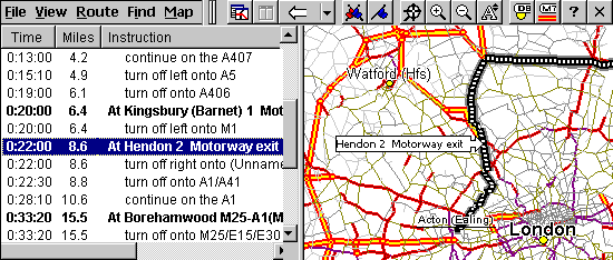
The Route Planner application – developed by UK-based Palmtop Software and available for all three rival OS platforms – is a good example of what’s on offer. The user indicates the required journey, either by pointing and clicking on a map or by entering the names of the start and destination points. Particular places of interest – or places to be avoided – can be entered before the route is calculated.
Any section of the road map can be displayed at any scale, and at any level of detail. Location names, routes, legends, locators and scales can be displayed in a variety of ways. Similarly, driving instructions can be displayed in several natural language formats and at different levels of detail. When used in conjunction with a compatible GPS satellite receiver, the traveler’s position on the map will be updated as they move. A split view allows progress along the route to be viewed at the same time as displaying the driving instructions.

Future mobile technologies are likely to have a major impact on lifestyles, both at work and play. Mobile banking and shopping can already be quite happily achieved on a small screen and, with an expected one billion mobile phone users by 2003, by then there may be as many people surfing the web via a mobile handset or mobile-enabled PDA as from their desktop – perhaps not for general-purpose Web surfing, but rather for accessing specialized Internet services like stock quotes, weather, maps and sports scores.